2 Votes (5.00 Moyenne) et 5.387 Vues  

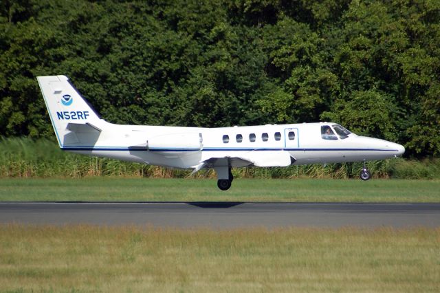
Cessna Citation II (NOAA52) - The Cessna Citation (CE-550) is a versatile twin-engine jet aircraft modified for acquiring remote sensing imagery. The aircraft is equipped with two equal sized camera ports which can support a wide variety of remote sensing configurations including large format aerial photography as well as data collection for digital cameras, hyperspectral, multispectral, and LIDAR systems.     Standard configuration includes space for two pilots, two equipment operators, and a scientific equipment rack. The aircraft can accommodate additional passengers depending on the amount of scientific equipment. The aircrafts unique side-by-side sensor port modification allows two different sensors to collect data simultaneously. The sensor ports have glass optical flats that allow the cabin to remain pressurized. Additionally, two high-precision GPS antennas provide signals to user receivers.     The Citation primarily supports the Remote Sensing Division of the National Geodetic Survey, collecting remote sensing data in support of coastal mapping and remote sensing research. Imagery acquired onboard the Citation is used for updating the shoreline and shore features on NOAAs nautical charts. The Citation also serves as an emergency responder during hurricane season by collecting digital photography of damaged areas caused by hurricane landfall.
/images/icons/csMagGlass.png moyen / grand / plein format

Cessna Citation II (NOAA52)

Soumis

The Cessna Citation (CE-550) is a versatile twin-engine jet aircraft modified for acquiring remote sensing imagery. The aircraft is equipped with two equal sized camera ports which can support a wide variety of remote sensing configurations including large format aerial photography as well as data collection for digital cameras, hyperspectral, multispectral, and LIDAR systems. Standard configuration includes space for two pilots, two equipment operators, and a scientific equipment rack. The aircraft can accommodate additional passengers depending on the amount of scientific equipment. The aircraft's unique side-by-side sensor port modification allows two different sensors to collect data simultaneously. The sensor ports have glass optical flats that allow the cabin to remain pressurized. Additionally, two high-precision GPS antennas provide signals to user receivers. The Citation primarily supports the Remote Sensing Division of the National Geodetic Survey, collecting remote sensing data in support of coastal mapping and remote sensing research. Imagery acquired onboard the Citation is used for updating the shoreline and shore features on NOAA's nautical charts. The Citation also serves as an emergency responder during hurricane season by collecting digital photography of damaged areas caused by hurricane landfall.

Comments

Please log in or register to post a comment.

JOURNAL DE L'ACTIVITE
Vous voulez une recherche complète sur l'historique de NOAA52 depuis 1998? Achetez maintenant. Recevez-le dans l'heure.
Date Avion Provenance Destination Départ Arrivée Durée
No Recent History Data
Les utilisateurs élémentaires (l'inscription est gratuite et facile !) peuvent voir 3 months d'historique. S'inscrire
 

Se connecter

Vous n'avez pas de compte? Inscrivez-vous maintenant (gratuitement) pour des fonctionnalités personnalisées, des alertes de vols, et plus encore!
Saviez-vous que le suivi des vols FlightAware est soutenu par la publicité ?
Vous pouvez nous aider à garder FlightAware gratuit en autorisant les annonces de FlightAware.com. Nous travaillons dur pour que notre publicité reste pertinente et discrète afin de créer une expérience formidable. Il est facile et rapide de mettre les annonces en liste blanche sur FlightAware ou d’examiner nos comptes premium.
Abandonner